Indian Drainage System Features & Patterns
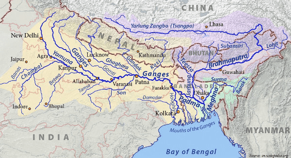
Himalayan Drainage vs Peninsular Drainage
| Himalayan Drainage |
|
| Peninsular Drainage |
|
West Flowing Rivers vs East Flowing Rivers of Peninsular India
| West Flowing Rivers |
|
| East Flowing Rivers |
|
Watershed
- Geographic area through which water flows across the land and drains into a common body of water, whether a stream, river, lake, or ocean
- Watershed boundary will more or less follow the highest ridgeline around the stream channels and meet at the bottom or lowest point of the land where water flows out of the watershed, the mouth of the waterway

Drainage basin
- Also known as catchment basin
- An area of land where surface water from rain, melting snow, or ice converges to a single point at a lower elevation.
- Usually converses at the exit of the basin, where the waters join another water body viz. river, lake, reservoir, estuary, wetland, or sea
- Hence it is an area drained by tributary streams that coalesce into a main channel
Watershed Divide
- The line, which divides the surface runoff between two adjacent river basins, is called the topographic water divide, or the watershed divide.
- It marks the highest points between the basins, but isolated peaks within a basin may reach higher elevations than any point on the divide.
Stream or Flowing River Patterns
- The combined effects of climate and geology on the catchment topography yield an erosion pattern, which is characterized by a network of streams.
- Some of the frequently observed stream patterns are as follows –

Dendritic River Pattern
- River channel follows the slope of the terrain
- Homogeneous beds of uniform resistance to erosion
- Streams run in all directions without definite preference to any one particular region
- Example > Indo – Gangetic Plains

Rectangular River Pattern
- Regions that have undergone faulting
- Provide uniform resistance to erosion
- Streams Meet at right angle approx.
- Develops on strongly joined rocky terrain
- Example > Vindhya Mountains of India

Trellis River Pattern
- River joined by tributaries at approx. right angle
- Develops in folded topography; alternate layers of hard & soft rocks
- Longer streams have preference to one direction
- Tributaries have preference to right angle to the main stream
- Example > Appalachian Mountains of North America & Singhbhum (Chotanagpur Plateau)

Radial River Pattern
- Streams flow in different directions from central peak
- Outflowing rivers, away from a central point, analogous with the spokes of a wheel
- Generally referred to rivers flowing through dome Mountains and volcanoes
- Example > Rivers Narmada, Son and Mahanadi originating from Amarkantak Hills; Girnar Hills (Kathiwar, Gujarat), and Mikir Hills of Assam

Pinnate River Pattern
- Main stream runs in one direction
- Tributaries join it at oblique angle

Parallel River Pattern
- Main stream runs in one direction
- Tributaries also join it running in the same direction
For more updates, explore the Geography . Feel free to share your thoughts and comments.
If you’re passionate about building a successful blogging website, check out this helpful guide at Coding Tag – How to Start a Successful Blog. It offers practical steps and expert tips to kickstart your blogging journey!


2 comments
thankyou very much to share the knowledge.
Quite impressive !!