Atmosphere – Weather and Climate
Weather > Pertains to the condition of atmosphere at any place at a specific time or for a short period of time (Generally for hours or days)
Climate > Average weather conditions of a specified area for a considerable time i.e. 30 – 35 years
- Generally, climate of temperate latitudes is far more variable than that of tropics.
- The climate of British Isle is so changeable that many people have commented that ‘Britain has no climate, only weather’.
- Conversely, the climate of Egypt is so static that it makes a good deal of sense when people say that ‘Egypt has no weather, only climate’.
- Death rates are normally high in tropical countries & low in deserts, because germs are not transmitted readily in regions of high temperature & low humidity.
- It is because of the variable water content in the atmosphere that we have such great contrasts in weather & climate over different parts of the world.
- If we were to live in a dry atmosphere, absolutely without water, there would be no weather & not much climate.
Elements of Weather & Climate
Rainfall
- Measured by Rain gauge
- An inch of rainfall means the amount of water that would cover the ground to a depth of 1 inch, provided none evaporated, percolated or drained off
- Daily record of rainfall will be added at the end of the month to find the total rainfall for that month
- Total for each month is again added at the end of the year to find the annual rainfall
- The mean annual rainfall is obtained from the averages of annual rainfall taken over a long period of say 30 -35 years
- For plotting in maps, places having the same mean annual rainfall are joined by a line called an isohyet
Pressure
- Measured by barometer, invented by Galileo & Torricelli
- Air is made up of number of mixed gases & has weight, therefore exerts pressure on the earth’s surface which varies from place to place & from time to time.
- As shown in diagram, variation in the atmospheric pressure on the mercury surface is balanced by a column of mercury in glass tube.

- Any liquid can be used for this purpose, but mercury has been chosen because it is the heaviest liquid known
- If ordinary water was used, corresponding column for normal atmospheric pressure would be 34 feet
- On map, places of equal pressure are joined by the lines called isobars
- Pressure reading at different places varies with a number of factors viz. Altitude, Gravitational forces at different latitudes & Temperature; due to sensitivity of mercury to it.
- A mercury barometer that dips in liquid mercury is inconvenient for outdoor measurements
- Hence a more probable but less accurate type known as aneroid barometer is used
- In airplanes, a modified type of aneroid barometer called altimeter is used & for continuous record of pressure changes a self-recording barogram is used.
Temperature
- Temperature is measured by thermometer, a narrow glass tube filled with mercury or alcohol.
- A temperature taken in open daylight is very high, as it measures the direct insolation of the sun, better described as temperature in the sun, used for measuring temperature for agricultural purposes.
- But the temperature that we are accustomed to in climatic graphs is shade temperature, i.e. temperature of the air.
- Hence, precautions must be taken to exclude the intensity of sun’s radiant heat, which is done by placing thermometers in a standard meteorological shelter known as Stevenson screen.
- Lines joining places of equal temperature in the map are termed as isotherms.
Importance of Temperature
- Temperature influences the actual amount of water vapour present in the air & thus decides the moisture carrying capacity of the air.
- It decides the rate of evaporation & condensation, & therefore governs the degree of stability of the atmosphere.
- As relative humidity is directly related to the temperature of the air, it affects the nature & types of cloud formation & precipitation
Factors influencing Temperature
| Latitude |
|
| Altitude |
|
| Continentality |
|
| Ocean currents & winds |
|
| Slope, Shelter & Aspect |
|
| Natural vegetation |
|
| Soil |
|
Winds
- The instrument widely used for measuring wind direction is a wind vane or weather clock
- The speed of the wind is generally measured by anemometer

Sunshine
- In meteorological station, sunshine duration is recorded by a sun dial
- On maps, places with equal sunshine duration are joined by isohels
Clouds
- When air rises, it is cooled by expansion & after dew point has been reached, cooling leads to condensation of water vapour in atmosphere.
- Tiny droplets of water vapour which are too small to fall as rain or snow will be suspended in the air & float as clouds
- The amount of cloud cover in the sky is expressed in eighths or Oktas for e.g. 4/8 is half covered & 8/8 is complete overcast
- On maps, places with an equal degree of cloudiness are joined by lines known as isonephs
Haze
- The term is usually used connection with the reduction of visibility in regions of low humidity
- This is caused by smoke & dust particles in industrial areas; or by unequal refraction of light in air of different densities in the lower atmosphere
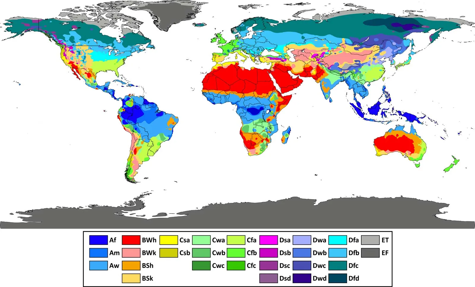
Koeppen’s Scheme of Climate classification
- Koeppen reorganized a closed relationship b/w vegetation & climate
- He based his classification on the amount of precipitation & temperature
- Divided earth in 5 major climatic group, 4 based on temp, 1 on precipitation along with cold climate of high lands
- The Koeppen system recognizes five major climatic types; each type is designated by a capital letter
| Tropical | A | Average temp. of coldest month > = 18*C |
| Dry Climates | B | Evaporation > Precipitation |
| Warm Temperate | C | Av. temp. of coldest month 18*C > x > 3*C (mid latitudes) |
| Cold snow forest climate | D | Average temp. of coldest month <= 3*C |
| Cold Climates | E | Average temp. of all month < 10*C |
| High Land Climate | H | Cold due to elevation |
| Amw | Monsoon with short dry season | West Coast below Goa |
| As | Monsoon with dry summer | East Coast Tamilnadu |
| Aw | Tropical Savanna | Most of the Peninsular plateaus, south of the Tropic of Cancer |
| Bshw | Semi-arid steppe climate | North-western Gujarat, some parts of western Rajasthan and Punjab |
| Bwhw | Hot desert | Extreme western Rajasthan |
| Cwg | Monsoon with dry winter | Ganga plain, eastern Rajasthan, northern Madhya Pradesh, most of North-east India |
| Dfc | Cold humid winter with short summer | Arunachal Pradesh |
| E | Polar type | Jammu and Kashmir, Himachal Pradesh and Uttarakhand |
Merits of Koeppen’s Scheme of classification
- Because of a visible association of vegetation with climatic types, Keoppen’s classification becomes all the more appealing to geographers.
- It is possible to assign a given place to a particular climatic sub-group only on the basis of certain easily acquired statistics about an area’s temperature and precipitation.
- This system of climatic classification is descriptive and generalized
- It uses a shorthand code of letters for the climatic types, so that repetition of descriptive terms becomes unnecessary.
- All the major climate groups, sub-groups, and further subdivisions are described by a combination of letters.
- This classification is so simple and detailed that it can be easily used at different educational levels.
Limitations of Koeppen’s Scheme of classification
- Koeppen based his classification on the mean monthly values of temperature and precipitation.
- By these statistics the most potent factor of precipitation can only be estimated, rather than measured accurately.
- It is empirical and, therefore, is based on facts and observations.
The causative factors of climate have been totally ignored. Thus, the air masses, which form the very basis of modern climatology, could not find any place in Koppen’s classification. - The letter symbols used by Koeppen in his climatic classification provide international shorthand describing climatic regions that are rather difficult to characterize in words.
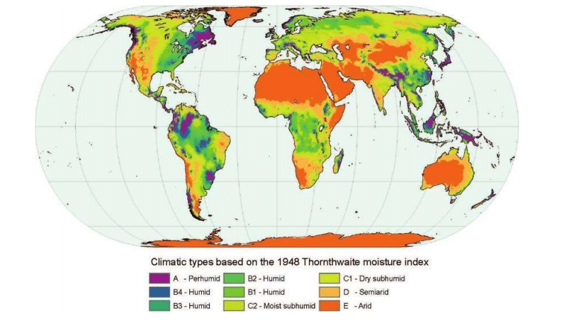
Thornthwaite Scheme of Climate classification
- It is based on concept of water balance i.e. rate of precipitation – rate of evaporation.
- An area is arid if there is water deficiency in all months
- An area is humid if it has water surplus in all months
For more updates, explore the Geography . Feel free to share your thoughts and comments.
If you’re passionate about building a successful blogging website, check out this helpful guide at Coding Tag – How to Start a Successful Blog. It offers practical steps and expert tips to kickstart your blogging journey!


2 comments
thankyou very much to share the knowledge.
Awesome articles….the most attractive feature is the use of visuals.
Thanks