
Atmosphere – Solar Radiations, Heat Budget, Temperature Inversion
Solar Radiations
- Maximum at equator & min. at poles (Due to earth’s inclination & its spherical shape, Sunrays fall perpendicular to equator, with inclination increasing from equator to poles)
- Larger the thickness / wideness of atmosphere, greater the scattering, reflection & absorption by the atmosphere, reducing the intensity of insolation on earth’s surface
- As beam of sunrays falls perpendicular to equator, hence if sunrays cross 1 unit of atmosphere here then they have to cross almost 44.7 units at poles
- That is why Insolation received per unit area is max at equator & min at poles
Specific Heat
- Heat capacity or specific heat of water is 5 times that of earth surface
- Which means same amount of heat will heat earth’s surface 5 times than that of water of same mass & vice-a-versa in case heat is withdrawn
- Hence land surface heats & cool more rapidly than water surface
- Specific Heat → Energy required to raise the temperature of 1 gm of substance by 1*C
- Rate of Heating differ between Water & Land because water is transparent to sunrays & is always in motion
- Hence heat is absorbed more slowly as absorbed heat is distributed over a great depth & area.
Heat Budget
- Earth maintains its temp. as amount of heat received by it in form of insolation = Amount of heat radiated by it through terrestrial radiation.
- Gain & loss of heat or balance of heat (Received & Emitted) is known as heat budget
Heat Received
- Total Solar Radiations → 100%
- Returned back to atmosphere in short wave form → 35% (Mainly from reflection & scattering from clouds, dust particles & from earth surface)
- Absorbed by atmosphere (mostly water vapour + Dust + Gases) → 14%
- Available to earth → 51% (34% from direct sunlight & 17% from scattered radiations) → Hence only 65% of total insolation is available for heating atmosphere.
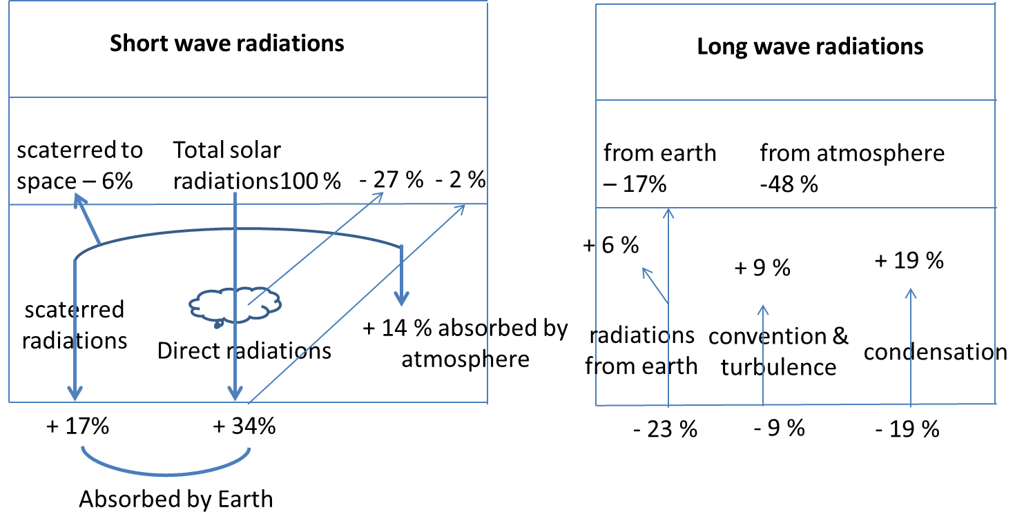
Note → Clouds act generally as mirror, reflects sunlight in different directions rather than absorbing it (Reflected sunlight is permanently lost to earth)
Heat Radiated
- Returned as long wave radiation form earth → 51 %
- 17 % radiated from earth surface
- 34 % absorbed by atmosphere (19 % + 9 % + 6 %)
- Now, 48 % (34 % + 14 %) absorbed by atmosphere is radiated to space by atmosphere.
Hence, Total Heat Received = Total Heat Radiated
Temperature Variation
- Under normal circumstances temperature decreases from equator to poles & each latitude has its own temp.
- But other factors such as altitude, oceanic currents, prevailing winds etc. also affect the temp. of a place.
- Hence, there lies a difference b/w temp. of a place & mean temp. of its parallel → Known as temperature / thermal anomaly

- If Expected temp. of a place (latitude) minus actual temp. of that place is negative then it is called negative anomaly & if positive then positive anomaly
- Due to more land area in northern hemisphere & more water area in southern hemisphere, largest of anomalies are found in N – Hemisphere & smallest in S – Hemisphere
Isotherms
- Imaginary lines joining places having equal temperatures, reduced to sea level to eliminate the effect of altitude
- Runs almost parallel to latitudes but modified somewhat due to influence of land & sea
- At any latitude, temperature over land mass is higher in summer & lower in winters compared to the temp. over sea
- Hence isotherms while crossing from landmass to oceans bend a little & vice a versa
- In January, there is winter in N – Hemisphere & summer in S – Hemisphere, means air over oceans is warmer than that over land masses in N – Hemisphere
- Hence isotherms bend equatorward while crossing the landmasses & polewards while crossing the oceans (Vice a versa in summers in N – Hemisphere) + Same logic for S – Hemisphere
- More water in S hemisphere results in uniform temp. mostly, hence less bends in isotherms → Trend is more clear here than at N – Hemisphere
- Distance b/w isotherms represents rate of change of temp., hence closely spaced isotherms indicate rapid change in temp. & vice versa.
Diurnal/Daily Range of Temperature
- Difference b/w max. temp. during day & min. during night;
- Sufficiently high at equator & gradually decreases towards poles
- Minimum near sea cost due to moderating effect of sea;
- Deserts have high diurnal range of temp. as sand absorbs & radiates quicker than land surface
- Cloud cover reduces daily range of temp. as it obstructs incoming radiations during day & outgoing radiations during night
Annual Range of Temperature
- Difference b/w average temp. of hottest & coldest month of the year
- Minimum at equator & max at poles
Temperature Inversion
- Under normal conditions, temp. of atmosphere fall with altitude
- But there are some special conditions under which temp. increases instead of decreasing with height.
- Means air near earth surface is cooler than that of higher place
- Factors which favour this condition are long nights, Clear sky, Stable weather, Dry air & Ice cover.
Air Drainage Temperature Inversion
- In mountain valleys, during long winter nights, air on higher slopes cool down quickly & become dense
- Hence move down the slope & settle down at valley bottom, pushing comparatively warmer air up
- Sometimes temp. at valley bottom falls below freezing point & air above at higher altitude remains comparatively warm,
- As a result, trees at lower slopes are mostly frost bitten than that of at higher slopes
- Houses & farms in mountain valley are generally situated along the upper slopes avoiding cold & foggy valley bottoms
- Air pollutants such as dust, smoke etc. do not disperse at valley bottom due to this reason

Radiation Temperature Inversion
- In areas, where there is rapid cooling of earth surface due to intense radiation from earth’s surface
- As a result air close to earth surface becomes cooler than air at higher elevation
- Generally occurs in winters

Advection Temperature Inversion
- In areas, where warmer air blows over colder surface
- Example → Snow covered area

Frontal Temperature Inversion
- When warm air mass rises over cold air mass
- Generally, occurs in mid latitudes where cold polar air mixes with warm subtropical air mass
- Lots of fog is generated


3 comments
thankyou very much to share the knowledge.
Hello,
Your content is really good. I was referring NCERT text books till now. But as came by you website, I felt I can understand your notes easily and better than NCERT as you have mentioned everything point wise and also with more pictures. I want to know whether I can replace my NCERT and read your notes only. Please do reply.
Im doing the same for end minute revision.